You are using an out of date browser. It may not display this or other websites correctly.
You should upgrade or use an alternative browser.
You should upgrade or use an alternative browser.
A Slightly Altered Version of the WCP Map
- Thread starter Chuckles
- Start date
Prometheus
Spaceman
Akwende Projection
Named after Dr. Shari Akwende, the discoverer of the Akwende (or "jump") Drive. The Akwende Projection depicts stars based on hierarchical jump point routes, naturally occurring hyperdimensional passages linking neighboring star systems. Jump points allow instantaneous travel for spacecraft with antigraviton engines between linked star systems. This map does not portray the absolute positions of individual systems, as exact galactic positioning is irrelevant when considering current methods of interstellar travel. Rather, it is set up as a base navigational aid in plotting jump routes. Star systems on this map are organized according to galactic-sector and sector-quadrant to which each system belongs and its position relative to other systems in the region.
That somehow reminds me of a similar "disclaimer" from the HyperSpace Star Map that came with Star Control II:
This map details the spatial relationship between the stars in our known region of the galaxy, as well as the spheres of influence for each alien race as of AD 2133. The positions are based on HyperSpace coordinates, which may be unsettling to some students of TrueSpace astronomy. Defined long ago by Chenjesu stargazers, the constellations are now accepted by all Alliance races as the standard. Due to the great difficulty in pronouncing the Chenjesu language, each race has translated the names into their own tongue. When it came time for Earth to adopt this system, the United Nations decided to use traditional astrological designations, assigned at random. This has caused some confusion, but it is considered preferable to the suggested alternative: using the names of past politicians.

Wedge009
Rogue Leader
The use of relative positioning instead of accurate reproduction of positions and routes is commonplace in every major city's public transport system, so it's not something limited to video game universes. Although, of course, the specific examples you cite do add their own in-universe reasoning for such charting schemes. 
Bob McDob
Better Health Through Less Flavor
It's not even necessarily physically relative, though - compare the positions of Venice and Cairo, or Seggallion and Rostov, to the original WC Vega Sector map - the former pair have switched positions; Rostov has apparently migrated galactic north of Seggallion.
Does this really matter? From a navigator's standpoint, not really - and I'm actually surprised at the degree of relative fidelity that was attempted converting the pre-jump node Wing1 map into the Prophecy-era map.
Does this really matter? From a navigator's standpoint, not really - and I'm actually surprised at the degree of relative fidelity that was attempted converting the pre-jump node Wing1 map into the Prophecy-era map.
Ilanin
Captain
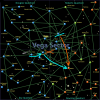
A further altered version...
Have to say I really like these maps, they're much simpler and easier to use than the CIC's big universe map (which I loathe due to it having far too many jump lines to be readable). They're also quite readily editable which is also good, because I'd love to have a 2654 map for example.
Any consensus on which systems should be recoloured for 2654? I've attached my version of Vega, done somewhat lazily...
Attachments

Wedge009
Rogue Leader
I think it would be difficult to state definitively which system was under what rule at a given point in time, especially given the fluid nature of war.
Also, an interesting side-effect of your redrawing of the boundaries is that Elohim in Downing Quadrant is effectively cut off from the rest of Humanity. That would be a rather tenuous position, I imagine.
Also, an interesting side-effect of your redrawing of the boundaries is that Elohim in Downing Quadrant is effectively cut off from the rest of Humanity. That would be a rather tenuous position, I imagine.
Ilanin
Captain
It actually isn't, but for what I can only assume are his own nefarious reasons, Chuckles has severed all the jump-lines between sectors. Elohim is linked to Torgo, in the Deneb quadrant of Epsilon Sector, and given that Confed decided to build the Behemoth there I'd be suprised if it wasn't also human in 2654, the shipyard must have been under construction if nothing else.
My algorithm is, roughly:
1) Change every world with a listed affiliation by a primary source to that affiliation (mostly Kilrathi worlds, also Rostov).
2) Where this creates Terran-controlled worlds surrounded by Kilrathi ones, flip those to Kilrathi also
3) Flip the smallest number of additional worlds to Kilrathi necessary so that they have contiguous borders.